The Mindanao Quake Turned Tsunami Alerts Into the Real Test
A magnitude 7.8 earthquake off Mindanao became more than a shaking story on June 8, 2026. It became a fast public test of how well the Philippines and the wider region translate seismic data into trusted, usable warnings.
Major earthquakes always produce two crises at once. The first is physical: ground movement, damage, injury, and the fear that comes when buildings, roads, and coastlines stop behaving like stable facts. The second is informational: how quickly officials can tell people what has happened, what threat still exists, and what they should do before rumor outruns science.
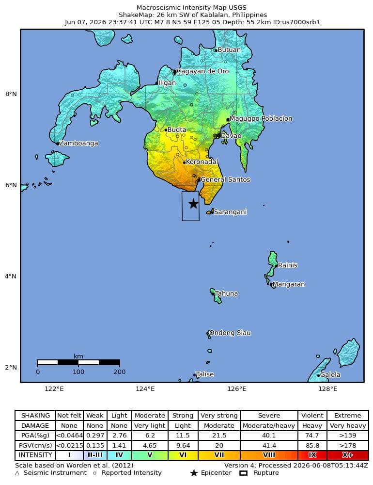
That second crisis is what made the June 8, 2026 earthquake off Mindanao more than a standard breaking-news item. The U.S. Geological Survey identified the event as a magnitude 7.8 quake about 26 kilometers southwest of Kablalan, Philippines, at 23:37:43 UTC on June 7, with an orange alert level and severe shaking estimates. The Philippine Institute of Volcanology and Seismology placed the quake at 7:37 a.m. Philippine time on June 8 near Sarangani, initially posted it at magnitude 7.0, and later raised it to 7.8 in its running event record.
That kind of revision is normal in seismology. It is not a sign of incompetence. But in real time, revisions matter because the public experiences them emotionally, not academically. A person deciding whether to leave the shore, wake family members, or abandon a damaged building does not hear magnitude refinement.
They hear uncertainty. The institutions managing a disaster therefore have to do more than be technically right. They have to be legible under pressure.
By late Monday morning in the Philippines, the human toll was already substantial. The Associated Press reported at least 12 deaths and more than 200 injuries, while rescue and damage checks were still continuing. Local live coverage from Inquirer.net showed how quickly the threat moved from shaking to evacuation guidance, with officials warning that the first tsunami waves could arrive between 7:37 a.m. and 9:37 a.m. and continue for several hours.
- 7:37 a.m. Philippine time: PHIVOLCS logged the offshore Sarangani quake and issued tsunami information for exposed coastal areas.
- Minutes later: PHIVOLCS' public event record showed the early magnitude estimate, which was later revised upward to 7.8 as solutions stabilized.
- 23:37:43 UTC: USGS listed a magnitude 7.8 event southwest of Kablalan and tagged it with an orange alert level for potential impacts.
- Roughly five hours after the mainshock: NOAA's U.S. Tsunami Warning System showed the tsunami threat as canceled, indicating the regional water threat had largely passed even as damage assessments on land continued.
The most important success was not perfect agreement. It was a working chain of warnings.
Readers often expect different scientific agencies to produce one instantly identical number. In practice, that is not how early earthquake response works. Agencies use different sensor networks, update cycles, and methodologies. What matters most in the first hour is whether the warning chain points the public in the same practical direction.
On that standard, the June 8 response looks more serious than sloppy. PHIVOLCS moved quickly to identify the quake and frame the coastal risk. NOAA's Pacific tsunami system reflected the event and its regional implications. USGS supplied globally visible magnitude, location, and shaking estimates. Those pieces were not cosmetically identical, but they converged where it mattered: this was a major offshore earthquake, coastal residents had reason to move, and the threat had to be treated as real before it could be treated as over.
| Agency | What it contributed | Why readers should care |
|---|---|---|
| PHIVOLCS | Local event timing, location framing, tsunami guidance, and continuing aftershock context. | It is the most important source for immediate public action inside the Philippines. |
| USGS | Global magnitude estimate, severe-shaking model, and event alert level. | It helps outside observers, regional partners, and international media calibrate the scale quickly. |
| NOAA/PTWC | Regional tsunami threat status and later cancellation notice. | It tells coastal communities and neighboring states when the water risk is rising and when it is easing. |
| Local reporting and AP | Damage, casualties, disruptions, and the pace of rescue information. | Scientific data explains the hazard. Local reporting explains the lived consequences. |
Why this matters beyond one morning in Mindanao
Earthquake warnings are exactly the kind of story that reveals how much modern public safety depends on ordinary civic mechanics. A regional warning system is a piece of international cooperation hiding inside everyday life. The value of it becomes visible only when the sea might move, roads might crack, and official language has to cross borders and devices quickly enough to matter.
The June 8 quake also exposed a harder truth: trust in a warning system is built long before a disaster. People comply faster when they already know which agency to watch, what an advisory means, and why an early number may change without invalidating the warning itself. If those habits are weak, every revision risks looking like contradiction instead of refinement.
The next test is what happens after the sirens fade
Even before lunchtime in the Philippines, the story was already moving into its second phase: aftershocks, structural inspections, school and bridge safety, coastal reassurance, and the politically sensitive business of counting the dead accurately. USGS listed a magnitude 6.5 aftershock southwest of Balangonan later in the sequence, a reminder that the first shock is rarely the only operational problem.
That is why the June 8 event should not be remembered only as a magnitude or a death toll. It should be remembered as a systems test. The Philippines did not need perfectly synchronized public numbers in the opening minutes nearly as much as it needed a credible chain of warning, evacuation, and follow-through. On Monday, that chain held well enough to matter.
The unfinished question is whether governments and agencies will use this event to improve the public explanation around revisions, coastal guidance, and aftershock communication before the next offshore quake forces the same lesson again.
Read Next
Related Stories

ASEAN Foreign Ministers Open Manila Talks as South China Sea Incident Raises Regional Stakes
ASEAN foreign ministers opened three days of meetings in Manila as a new incident near Second Thomas Shoal and the wider Iran crisis put maritime security and energy routes at the center of regional diplomacy.

South-Central Texas Flooding Triggers Flash-Flood Warnings After Up to 16 Inches of Rain
National Weather Service warnings describe life-threatening flash flooding across south-central Texas after 6 to 16 inches of rain fell in parts of Uvalde County.

Bangkok Bar Fire Death Toll Reaches 32 as Safety Investigation Widens
The Bangkok bar fire has killed at least 32 people and injured more than 70, while survivors seek compensation and investigators examine evacuation conditions and possible safety failures.